 Public domain
Maps and Geography
Before you can judge a history, you need a sense of where it happened.
This page answers three questions.
Where did they mean to go. Where did they actually land. What did this place look like before they came.
Each section closes with a tag for how strong the evidence is:
VERIFIEDsources agree |DISPUTEDscholars or institutions differ |UNAUDITABLEno traceable source found
1. The place they were aiming for is not today's Virginia
Hold on to one sentence.
The target was New York, not the state of Virginia.
That sounds like a correction. It isn't. Both ways of saying it are true, and they do not contradict each other.
In 1620, the English word "Virginia" was a big, loose idea.
It meant a whole stretch of the North American east coast granted by the English crown, running roughly from today's South Carolina north to about today's New York.
That territory was split into two patents.
- The Virginia Company of London held the southern part. Its centre was Jamestown, founded in 1607, in what is now the state of Virginia.
- North Virginia held the northern part.
The patent these passengers carried belonged to the northernmost edge of the London Company's jurisdiction.
Their stated destination was specific: the mouth of the Hudson River.
In the geography of the time, that was understood as the northern boundary of the Virginia grant.
The mouth of the Hudson, in today's names, is New York City and northern New Jersey.
So:
"They were going to Virginia" means the big idea. "They were going to the mouth of the Hudson" means the specific northern point inside that idea.
They were not going to Jamestown.
Four places you can find on a modern map:
| What they called it | Where it is today | Relative to Plymouth |
|---|---|---|
| Target: mouth of the Hudson | New York City / lower Manhattan | about 340 km southwest |
| Centre of the Virginia colony | Jamestown, Virginia | further south; not the destination |
| Where they actually anchored and signed | Provincetown Harbor, tip of Cape Cod | about 40 km across Plymouth Bay |
| Where they finally settled | Plymouth | today's Plymouth |
VERIFIED
2. Why they never got there: the shoals at Pollock Rip
The Mayflower sailed from Plymouth, England, on 6 September 1620, with 102 passengers.
The crossing took 66 days.
On 9 November they sighted the highlands of the outer arm of Cape Cod.
That was already far north of the target. So they tried to work south along the coast toward the Hudson.
Rounding the southern end of Cape Cod, some nine miles out, they met Pollock Rip - shoals and hard currents.
The wind was against them. The season was already late. Supplies were running out.
They turned back.
On 11 November the Mayflower anchored in Provincetown Harbor.
That turn had a direct consequence.
They had stopped in a place their patent did not cover.
That is the immediate reason the Mayflower Compact was written - to keep a company of people from breaking apart on a shore no charter governed.
For about a month afterwards they used the shallop to explore Cape Cod Bay. Only in mid to late December did they cross the bay and settle at Plymouth.
One line to remember:
Aiming for New York, blown north to the tip of Cape Cod where they signed the Compact, then across the bay to settle at Plymouth.
VERIFIED
(No precise latitude or longitude is claimed anywhere on this page. UNAUDITABLE)
3. The Compact was not signed at Plymouth
This is the geographical fact people get wrong most often.
The Mayflower Compact was signed at anchor in Provincetown Harbor, at the tip of Cape Cod.
Not at Plymouth.
In November 1620 the ship lay there, and the adult men aboard signed it aboard the ship.
At that moment they had not yet seen the place that would be called Plymouth.
Two related things worth stating plainly.
The signed original sheet is lost.
The full text we read today survives as a copy in William Bradford's manuscript Of Plimoth Plantation - about 195 words.
As for how many men signed, accounts differ, and no fixed number is given here.
The familiar list of 41 signers comes from a single source: a book published by Nathaniel Morton in 1669, forty-nine years after the fact.
VERIFIED (place of signing) DISPUTED (number of signers)
4. This bay before 1620
Now move back fifteen years.
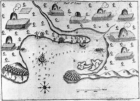
In 1605 the French navigator Samuel de Champlain surveyed this coast and labelled the harbour Port St. Louis.
His survey was published in 1613.
This is the same place the English would call Patuxet - the ground Plymouth was built on.
The map predates the Mayflower by fifteen years.
And by the record of that map, it does not show empty ground. It shows Wampanoag houses and worked fields.
That matters, because the English later used a Latin phrase for this coast:
vacuum domicilium - "vacant dwelling place."
On a survey from 1605, it was a populous village.
So where did the emptiness of 1620 come from?
From the epidemic that swept coastal Native communities between 1616 and 1619 - the Great Dying.
The scale is disputed. The museum's panels give 70-90% of the region's population; the journal literature gives a wider range and says plainly that reliable data are lacking. The cause remains undetermined, which is why this page does not call it a plague.
The map is the evidence. The emptiness came later.
This section establishes one thing only: this land was inhabited and farmed before 1620.
What that history means to the Wampanoag is for Wampanoag people to say. This page does not draw that conclusion on their behalf.
VERIFIED (date and content of the map) DISPUTED (scale and cause of the Great Dying)
5. "New Plimouth" was on the map four years before they arrived
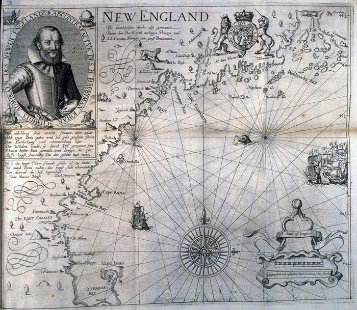
In 1616 an engraved map was published in England.
It was drawn by Captain John Smith.
He had surveyed Maine and Massachusetts Bay in 1614, and on this sheet he used the name "New England" for the first time.
Smith asked Prince Charles, then about fifteen, to replace the Native place-names with English ones.
Later settlers kept only three of them: Cape Ann, Charles River, Plymouth.
Which means:
The name "Plymouth" was printed on a map four years before any of these passengers saw the place.
And it sat exactly on the Patuxet site where they would settle.
They did not name this place. They inherited a name that was already there.
The map has one limitation that happens to explain section 1 perfectly.
It shows only New England - north of Cape Cod.
It does not reach the mouth of the Hudson.
So:
The map was of New England, but the destination was off the map.
Plymouth, where they ended up, was already on it.
One more thing has to be said alongside this.
They used Smith's map, but they did not use Smith the man.
In 1620 they did consider hiring him as a guide, and passed him over - they were wary of his temper - taking Myles Standish as military leader instead.
And the map's origin is not innocent.
It came out of Smith's 1614 expedition - the same voyage whose shipmaster, Thomas Hunt, seized Tisquantum and more than twenty others to sell in Spain.
Tisquantum was a Patuxet man.
When he was taken, his village was still there.
VERIFIED
6. The five maps, one at a time
The site holds five public-domain original maps.
For each: who drew it, when, what it records, and what it leaves out or distorts.
Champlain, "Port St. Louis" (surveyed 1605, published 1613)
What it records: this harbour as it stood fifteen years before the Mayflower, with Wampanoag houses and worked fields. This was Patuxet, a populous village.
What it sets against: the English would later call this coast vacuum domicilium, a vacant dwelling place. This map exists before that phrase.
What to keep in mind: it is a French survey, made for French exploration and trade. Not a neutral record.
John Smith, "New England" (engraved 1616)
What it records: the first use of the name "New England"; the anglicized place-names, among them "Plimouth," printed four years before the fleet. Laid over a modern map it holds to within about ten miles overall - far better than anything else of its period. Cape Cod appears under its older name, Cape James.
What it leaves out: its southern limit is Cape Cod. The mouth of the Hudson - the actual destination - is not on the sheet.
What it distorts: it systematically replaces the Native place-names of this coast with English ones. Naming is already a form of taking.
Where it came from: the 1614 expedition on which men were seized and sold.
William Wood, southern New England (London, 1634)
What it records: Plymouth shown as an established town only fourteen years after 1620. It appeared in Wood's New England's Prospect, one of the first eyewitness English books about the region.
But read the rest of the sheet: it is dense with Wampanoag and other Native place-names. This coast had already been mapped and named by the people who lived on it.
Where it stands: this is a settler's map, drawn to attract more settlers. Use it as evidence of the actual landscape, not of an empty one.
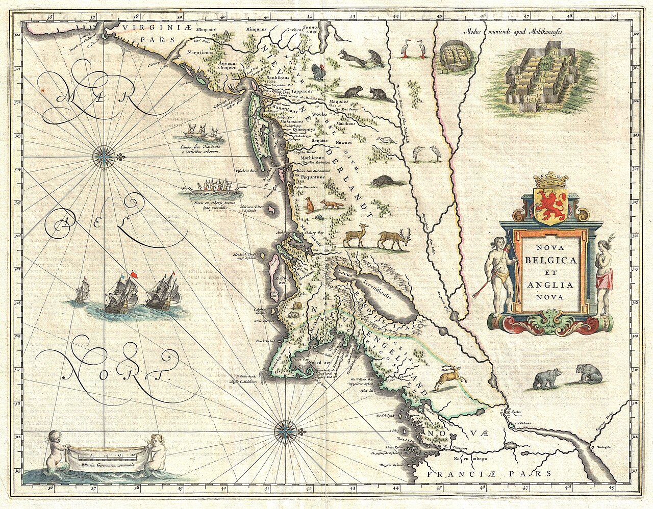
Willem Blaeu, "Nova Belgica et Anglia Nova" (Amsterdam, 1635)
What it records: one of the most beautiful maps of the era, and the first to show Manhattan as an island.
What it corrects: it frames New England not as a lonely Pilgrim frontier but as one corner of a crowded, contested coast - Dutch traders to the south, English to the north, and everywhere the names of Native nations: Wampanoag, Narragansett, Pequot, Mohawk.
The claim it undoes: the "errand into the wilderness" was an errand into a place already full of people, powers and maps.
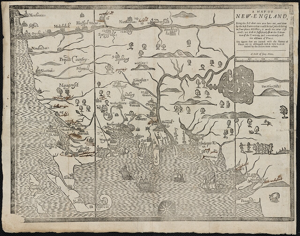
John Foster, "A Map of New-England" (Boston, 1677)
What it records: the first map ever printed in British America. Its own title boasts that it is "the first that ever was here cut."
But notice its purpose: it was made to illustrate William Hubbard's narrative of King Philip's War (1675-76) - the war in which the alliance of 1621 ended in bloodshed.
What it is at the same time: a technological first that is also a war map. The achievement and the violence sit on the same page.
VERIFIED
One honest note about this page
Everything said here about these five maps rests only on traceable written sources.
Any detail on the sheets that the sources do not state plainly - the exact border, the scale, the ornament, the precise position of a given place-name - is not written here.
The easiest thing to do when describing a map is to add a few details that sound reasonable. This page would rather say less.
For the same reason, no precise coordinates are given. All distances are approximate: about 340 km southwest, about 40 km across the bay, 66 days at sea.
Sources
- Bradford, Of Plimoth Plantation
- Britannica - Mayflower / Plymouth Colony
- Library of Congress; Osher Map Library - New England Defined
- Historic Chatham - The Mayflower Story
- MayflowerHistory.com - Voyage
- Smithsonian Magazine (2021) - Smith's map, and the decision not to hire Smith himself
- Boston Rare Maps (Burden #187); Digital Library of Georgia - the 1616 Smith map and its states
- Plimoth Patuxet Museums exhibits and interpretive panels
- All five maps are public domain; scan credits appear with the images on the site
 Public domain
 Public domain
 Public domain
 Public domain